
CLIMATE CHANGE AND URBAN INFRASTRUCTURE IN RELEVANCE TO HYDERBAD FLOODING
Photo by PTI

BY GURLEEN KAUR MATHARU
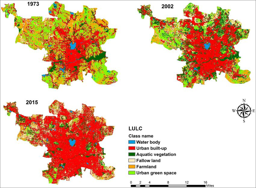
Industrial boom and development has caused linearity to fade away. Opportunities have resulted in growth, which is turn has engendered various forms of urban settlements; linear, nuclear and dispersed, in which the latter two have seem to inhabit most of the realm. Urbanization is a resultant of this dramatic social-economic growth and population outburst, which has led to redefine our land use and green cover, something which is strategically guided beforehand by a group of planners, architects and engineers, to have a controlled urban and ecological equilibrium. Technology, infrastructure, etc has brought upon unforeseen forces like rapid migration from rural to urban areas, creating metropolitan sprawls, farmland displacement, and deforestation, leading to the loss of arable land, habitat destruction, and the decline of natural greenery areas. This is only going to worsen in the coming years, and with the declining rate of earth’s natural systems, redistribution of population, revising policies of ascertaining equal socio-economic-political advantages for all classes of people, evidently requires to be intervened.
Over the last few years, major Indian cities have been facing the brunt of climate change. Hyderabad for example, has experienced some of the worst flooding this year which has not only claimed many lives but is still struggling to seek asylum from the aftermath. A deep monsoon depression over the west central Bay of Bengal, which weakened as it moved over Telangana, resulted in downpours over several districts in the State, severely affecting the city of Hyderabad as well. But the underlying reasons remain unchanged. Change in land use/cover, encroachment over low-lying areas, drains, lakes, wetlands, water logging and increase in garbage dumping grounds, which in turn has increased the rate of run-offs. The adverse effects of urbanization have led to excessive inundation of storm water drainage systems. Hence even small quantity of rainfall is bound to cause flooding. Moreover, a weak and disorganized storm water drainage system (SWDs) in the city has caused the other SWDs constructed my gram panchayats to turn into sewers.
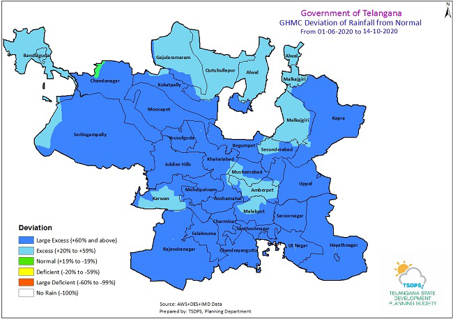
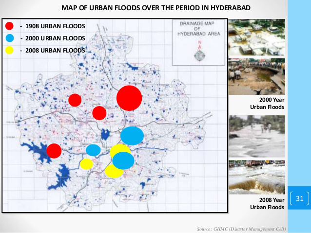
Hyderabad city recorded its third wettest day in October, and had received 356mm of rains in 18 days, four times the normal amount of rains usually witnessed. The twin reservoirs of the city, namely, Osmansagar and Himayatsagar were commissioned to build as a resultant of 1908 flooding, which is also known as the Great Musi Flood of 1908, occurred on the banks of Musi river. These reservoirs have been seen to reach their full capacity this year. The incessant rains have also caused the water level at Hussain Sagar to cross its full tank capacity. Transformation in hydrogeology in turn, has led the city to be exposed to more number of cyclones in very short duration.
Given the agrarian character of the Hyderabad land, it was originally a system of catchments. But illegal and aggressive real estate growth, construction of roads and poor waste management has taken a toll on the natural resources. Even the floodwaters carrying channels connecting one water body to the other have been encroached by private, government agencies, and their coalitions. With a decrease in forest cover, an increase in recreational groundcover, parks, and urban vegetation can be identified in both urban and sub-urban areas of the city. These have been largely occupied over lakes and ponds, with the sole purpose of boosting the tourism market and offering attractive township facilities. Concretization on the other hand has occasioned impervious surfaces and prohibited percolation of rainwater through the soil.
With the city in turmoil, one needs to look back at the policy framework entailing flood mitigation and risk assessment. With a loss of thousands of hectares of water bodies over the years, strict buildings regulations and monitored bye-laws on urban infrastructure need to be imposed, while assuring a strong and unassailable relationship between the stakeholders and shareholders.
For Hyderabad, the policy changes and their implementation have been weakly reinforced on grounds. Calculating and studying the technicalities of land use and flood prone areas using GIS tools, could not refrain the government from financing various projects across the city. These policies are also often steered by neoliberal ideologies which fail to amalgamate development progression with disaster management. Their failure to identification of environmental vulnerability and delay in administering an efficient system to provide symmetry for a self sustaining city has created a lag in ensuring a sustainable future.
The recent floods in Hyderabad has not only caused major destruction to roadways and colonies, but also displaced so many families and deprived them of basic necessities like food and water. Chief Minister, K Chandrasekhar Rao (KCR) has estimated the state’s losses at around ₹5,000 crore and sought immediate relief of ₹1,350 crore from the Centre. Farmers face loss of ₹2,000 crore with crops in over 7.35 lakh acres submerged.
Although the building authorities have laid out the bye-laws for a systemic distribution of private and public services, but at a micro-level, these fail to achieve their mark, resulting in settlements over and around floor prone sectors. Master planning schemes need to take into account the socio-environmental dynamics, rain water harvesting, treated drinking water, electricity, climate resilient structures, clean green energy to reduce pollution, limitations on mining, etc.
Co-ordination and autonomy between authorities with regards to irrigation, real estate, revenue and urban infrastructure is imperative for the commonwealth, such as the Hyderabad Metropolitan Development Authority (HMDA), Greater Hyderabad Municipal Corporation (GHMC), National Disaster Management Authority (NDMA) and Industrial Area Local Authorities (IALAs).
Climate change is an onset of impetuous human conduct, which has been acted upon without any acknowledgement of its affects on environment and its degradation. Sustainable development of the city and of the nation is always in conflict with consumerism. And the effect of this reckless decision making is always reflected on the economically weaker section. As per the last census 2011, there were 2.29 million people residing in slum and squatter settlements in Hyderabad. As per GHMC’s own estimation, there are 13,509 families directly vulnerable to flooding in the city.
State owned entities, local bodies and government enterprises need to have full transparency in commercial, residential, institutional and public sectors. Migration and population growth are irrepressible, a majority of public will be living in urban settlements for years to come. Urbanization is not a problem of the rich or poor, but both, and it can be only be reciprocated with a Greener growth.
REFERENCES:
1. Vemana, Raghuteja & Srivalli, Kosuru. (2020). URBAN FLOODS A STUDY SPECIFIC TO HYDERABAD AND VIJAYAWADA CITIES.
3. Overcoming Barriers to Urban Flood Resilience: A Case of Hyderabad, India, By Vikas Sehra and Milap Punia
ABOUT THE AUTHOR
Gurleen kaur Matharu
If you wish to get in touch with the author of the article, you can email her at
Gurleen is an architect specializing in sustainable building technology. She is also an artist, experimenting with plastic waste is of her artistic traits. Driven by determination, her goal is to celebrate a healthier Earth by integrating and prioritizing net zero applications.
Very nice article giving a detail analysis regarding all the scenes and scenario for the points with a schedule plan showing details of land coverage too.