
ASSAM FLOODS AND CLIMATE CHANGE: ADDRESSING THE ELEPHANT IN THE ROOM

BY MANISHA DUTTA
Flood in Assam is an annual phenomenon. Across the years, it has aggravated and disproportionately affect populations in the lowest economic strata in the state and the marginalised communities whose livelihood, shelter and access are disrupted. Floods have been seen essential for this region as it rejuvenates the alluvial soil and make the river basin one of the most fertile areas for cultivation. But the massive disruption and displacement caused by the severe floods no longer seems a welcome option and rather must be regarded a national calamity.
This year the ongoing floods have wreaked havoc in the state, further amplified by the rampant COVID-19 pandemic. Between 22nd May, 2020 and 9th August, 2020 [1] 30 districts in Assam with 5,378 villages have been affected by the floods. A total of 5.68 million population have been severely affected with the death toll reaching 110, caused by floods and 26 deaths caused by landslides. About 39,667 houses have been damaged and over 2.6 lakhs (hectares) crop areas have been damaged.
A time trend analysis demonstrates that compared to the past two years, 2020 has been the worst flood affected year as the numbers continue to soar:
| Table Header | As on 9th July 2020 | As on 9th July 2019 | As on 9th July 2018 |
|---|---|---|---|
|
No. of districts affected |
24 |
8 |
3 |
|
No. of Villages Affected |
400 |
145 |
30 |
|
Population affected |
1,82,583 |
62,419 |
22,618 |
|
Total crop area affected (in hectare) |
26,676.25 |
3435 |
858.3 |
Source: Daily Flood Report; Assam State Disaster Management Authority [2]
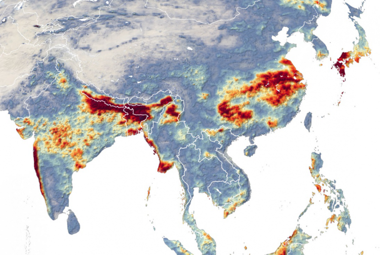
The very pertinent question on what causes the floods in Assam has several responses. Firstly, the Brahmaputra valley occupies 56,194 km2 area of the total 78,438 km2 area of Assam [3]. The flood prone areas of the state make up 40% (including the Barak river valley region) of the state, which is 9.4% of the total flood prone area of the country [4]. The Brahmaputra, with massive volumes of water meanders through steep slopes across Tibet, China and Arunachal Pradesh and enters the plains in Assam. As it reaches the plains and spreads into numerous tributaries, the river gives way to massive siltation thus raising the water levels. The second attribute is related to the northward and north-east movement of moisture carried by south-westerly winds through the monsoon trough every year from the Bay of Bengal, causing rainfall. The third attribute pertains to the cyclonic circular pressures that drifts northwards and north-east from Orissa-Bay of Bengal that triggers rainfall in its aftermath.
A Study in 2017 by Indian Meteorological Department, Pune [5] had undertaken a time-trend analysis of rainfall patterns in Assam between 1981 and 2016. It demonstrated that the mean monsoon rainfall had significantly declined across the years in Assam and different parts of the north-east. And yet the two decades had seen the worst devastating floods in the state in the years 2002, 2004, 2012, 2017 and 2020. Thus, the contradictions of declining annual rainfall and increased intensity of floods co-exist in the state. One of the key reasons of this is that while mean annual rainfall has declined, the sudden bouts of heavy rainfall for a day or two at stretch is enough to cause massive rise in the water levels of Brahmaputra. Take for instance, between June 01 and July 22 of 2020, the rainfall in Assam was 89 cm, 20% higher than the normal rainfall in the year. These bouts of heavy rainfall compound with the complex river system of the Brahmaputra that has the propensity of swelling up and change courses rapidly resulting in submergence of low-lying areas.
Several solutions proposed, have revolved around ensuring flood management specific to the region spanning from building of embankments to dredging to long term plans of integrated water basin management. Similarly, both structural and non-structural solutions look at local solution for the local problems. However, what remains as an elephant in the room is addressing the vagaries of climate change of which floods are the visible after-effects. And the emphasis on climate change requires a national priority, national vision, political willpower to initiate cross-border understanding and prioritising efforts towards reducing global warming.
Integrated Flood Management, an internationally recognised and holistic approach emphasises on how climate variability impacts the distinct patterns and intensity of floods. In the concept note, they elucidate it as follows:
“The management of floods as problems in isolation almost necessarily results in a piecemeal, localized approach. Integrated Flood Management calls for a paradigm shift from the traditional fragmented approach…”
Political willpower and systemic solutions to adopt the integrated flood management approach is still a distant milestone for Assam. At a national level, it is high time that climate change is reflected within the discourse of national disaster management narratives be it cyclones, floods or droughts. One of the critical needs is for adaptive solutions to flood management that consider the rapid climate vagaries of the region. This requires going back to the roots -how climate change is responsible for intensity of the floods. Global warming is a pressing problem and has led to record high temperatures across cities in the globe every year. At the same time, this global warming is leading to further heating of water masses and rapid melting of glaciers. A 1c rise in sea temperatures could cause massive, frequent, and sustained cyclones especially when surrounded by land mass from more than half the sides in the Bay of Bengal region. 26 of the 35 deadliest cyclones have hit Bay of Bengal caused by sea surface temperature triggering tropical storms and heavy rainfall.
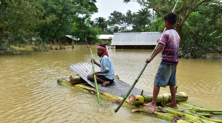
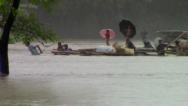
Picture Courtesy: Press Trust of India
Global warming has also caused rapid melting of glaciers both in the Himalayas with 8bn tonnes of ice being lost every year irreplaceably and the average rate of ice loss doubling in the 21st century, according to a Study conducted in 2019 [6]. Melting glaciers that form part of the river origins have a direct effect on the volume of water and siltation caused by huge rivers such as Brahmaputra when they flow from a very high altitude through the plains leading to floods. This is further compounded by the topography of the Assam plains in which the earthquake of 1950 has created several areas higher prone to flooding when the river waters of the Brahmaputra soar up.
To aggravate this further, human activities have led to further deterioration of natural mechanisms of flood control. Wetlands, that play a vital role of cushioning and absorbing excess waters are being depleted in the region by turning them into dumping grounds for garbage disposal or damaged by industrial activities. Furthermore, large scale deforestation and unplanned settlements across the floodplains are leading to massive erosion in the river basin expanding the breadth of the river to 6,080 sq.km by 2006 with some places the width expanding from 5.46km to 15kms. On an average, the annual erosion rate in the state is 8000 hectares.
While several shortcomings remain in terms of implementation of flood management strategies (both in terms of long-term and short-term) what remains unaccounted is the effect of climate change and taking at as a national priority. Global warming is real, and its impact has national and international repercussions. Therefore, it is now or never that India needs to embrace the realities of climate change and come up with strong climate action policies aimed at reduction of greenhouse emissions and lowering carbon footprint. Simultaneously, disaster plans need to recognise the impact of climate vagaries and draw integrated support to mitigate natural calamities.
References
1. Assam State Disaster Management Authority. Cumulative Flood Report. Available from: http://asdma.gov.in/pdf/asdmp.pdf
2. Assam State Disaster Management Authority. Daily flood Report. Can be accessed: http://asdma.gov.in/reports.html
3. Directorate of Economics and Statistics. 2016. Department of Agriculture and Cooperation, Government of Assam
4. Gov. of Assam. Flood and Erosion Problems. https://waterresources.assam.gov.in/portlets/flood-erosion-problems
5. Ministry of Earth Sciences. Observed Rainfall Variability and Changes over Assam State. India Meteorological Department Pune. 2018. Available from: http://imdpune.gov.in/hydrology/rainfall%20variability%20page/assam_final.pdf
6. Maurer J.M., Schaefer J.M., Rupper S., Corley A. Acceleration of ice loss across the Himalayas over the past 40 years. Science Advances. 19 Jun 2019. Vol. 5, no. 6, eaav7266. DOI: 10.1126/sciadv.aav7266
ABOUT THE AUTHOR
MANISHA DUTTA
If you wish to get in touch with the author of the article, you can email her at [email protected].
Manisha Dutta is a Global Shaper of the Global Shaper Guwahati Hub, which is a part of the Global Shapers Community, an initiative of the World Economic Forum. She was part of the July 2020 batch of the Climate Reality Leadership Training Corps and carries several years of experience working with rural and marginalised communities
Nice written. Very informative.